|
Geologic Trip Steens Mountain |
|
USGS |
|
Head of Little Blitzen Gorge |

|
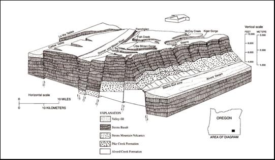
Steens Mountain (9773’)
is a large mountain in southeast Oregon that has characteristics of two major
geologic provinces that overlap in this area—the Basin and Range Province to
the south and the Columbia River Basalt Province to the north. The mountain
is formed from a large fault block of basalt that has been uplifted and
tilted to the west. The fault block is part of the Basin and Range Province
and the basalt is part of the Columbia River Basalt Province. The east side of the
fault block is a steep rugged fault escarpment that rises over 5,000’ above
the Alvord Desert. The west side is a gentle slope that extends for about 20
miles to the Catlow Valley and Frenchglen. At high elevations the gentle
western slope is dissected by several gorges that were dug by glaciers during
the Pleistocene ice ages. 1
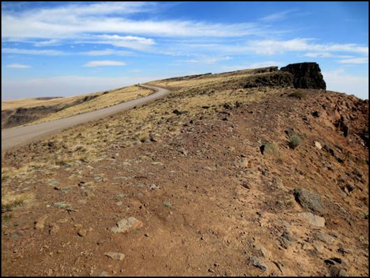
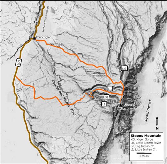
The Steens
Mountain Backcountry Biway goes up the gentle western slope of the mountain and provides access to
the crest. This 52-mile gravel road consist of two segments. The north loop
extends from Frenchglen to the crest of the mountain and is a good gravel
road suitable for passenger cars. Along the way there are good views of the
Kiger and Little Blitzen Gorges. The south loop has segments that are rough
and steep and is not suitable for low-clearance cars or trailers. The loop
road is closed in the winter due to snow, and may be closed by weather at
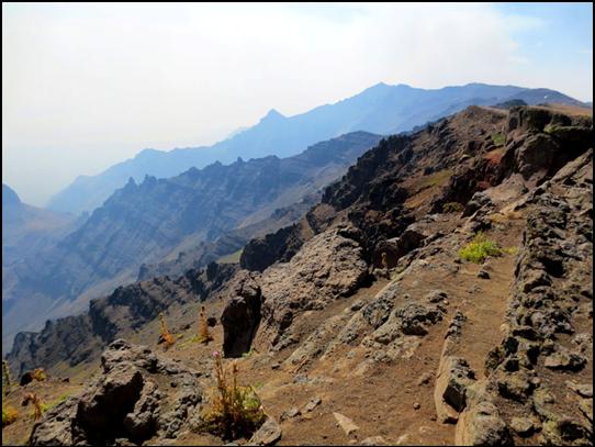
other times. 2 The photo looks north
along the crest of Steens Mountain and shows the north loop road near the
head of Little Blitzen Gorge. The gorge is on the left and the east
escarpment of Steens Mountain on the right. In this area, the loop road will
eventually be cut by eastward erosion of the Little Blitzen Gorge and by
westward erosion of the eastern escarpment. Note the gentle west slope of the
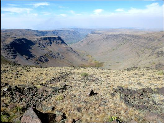
top of the fault block. 3 The photograph looks
west down Little Blitzen Gorge from the head of the gorge near the loop road.
The gentle flat surface above the gorge is the top surface of the west
dipping fault block. Little Blitzen Gorge
was carved into the fault block by glaciers during the Pleistocene ice ages,
beginning about 1.6 million years ago. The glaciers left the steep sided
U-shaped valley that can be seen in the photo. Nearby Kiger and Big Indian
Gorges were formed in a similar manner.
The Steens basalt is
well exposed in the seep walls of Little Blitzen Gorge. The layers in the
basalt were formed by numerous basalt flows. The flows dip gently west,
following the west tilt of the Steens Mountain fault block. 4 This photograph from
the crest of Steen Mountain looks down the eastern escarpment of the mountain
toward the Alvard Desert, which is obscured by smoke from fires south of
Steens Mountain. The west-dipping basalt is well exposed along the escarpment
(white lines). During the ice ages, glaciers cut cirques in a number of
places along the eastern scarp. 5 The basalt flows at
Steen Mountain are referred to as the Steens Basalt and are over 3000’ thick.
The eruptive center is thought to be in the area of the Pueblo Mountains, a
few miles south of Steens Mountain. The eruptions began about 17 million
years ago and lasted for 1.5 million years. These eruptions occurred at the
same time as the other flood basalts of the Columbia River Basalt Province. Many of the basalts at
Steens basalts have large flat white crystals of plagioclase feldspar that
help distinguish this basalt from other Columbia River basalts. The faulting that
uplifted and tilted the Steens block to the west began about nine million
years ago and is still in progress. The fault zone is about 30 miles long,
with maximum uplift of about 7000’. The Steens block is broken into a number
of large segments by other faults, as shown in the diagram. As the Steens block was
uplifted the Alvord Valley dropped down and began collecting sediments from
the eroding fault scarp. These sediments are now about 2000’ thick. Lakes
developed in the Alvord Desert during Pleistocene ice ages, and then
disappeared about 10,000 years ago. Note Steens Mountain lies within the Steens
Mountain Cooperative Management and Protection Area which includes a number
of private and public lands. For more information contact the Bureau of Land
Management, Burns District. External Websites Bureau of Land
Management:
Steens Mountain USGS:
Geologic Field-Trip Guide to Steens Mountain Wikipedia:
Basin and Range Province,
Steens Mountain,
Columbia River Basalt Group Return to:
Home |
|
Eastern Escarpment Steens Mountain |