|
Sea Ranch Geologic Trips |
|
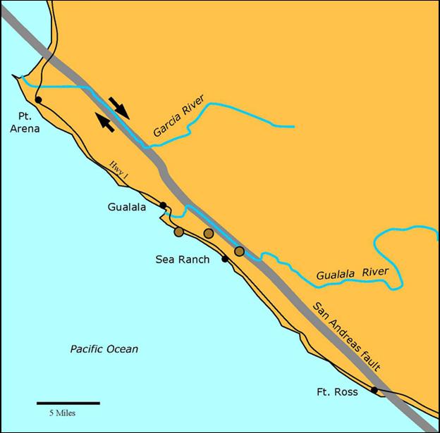
After the San Andreas Fault leaves
San Francisco, it plays tag with the California coast, coming ashore at the
Point Reyes Peninsula, Bodega Bay, and finally at a stretch of the coast from
Fort Ross to Manchester Beach. The rocks in this last segment are mostly
sedimentary and were deposited in the Gualala Basin
during late Cretaceous to Miocene time. We don’t know exactly where the
Gualala Basin was when it started its trip north, but it was probably
somewhere in southern California or Baja California.
Geologic Background,
Sea Ranch Places to See the Rocks
Bluff (pdf): A geologic trip
along the Sea Ranch bluff provides a good opportunity to visit with these
well-traveled rocks.
Meadow and Hillside (pdf): The meadow
and hillside at the Sea Ranch have been sculptured by wave action to form a
series of wave-cut terraces during the last 500,000 years.
San Andreas Fault (pdf): Walk along
the San Andreas fault at the Sea Ranch and see ridges and sag ponds that were
formed by movement along the fault. The Sea Ranch is private property.
Non-residents should contact the Sea Ranch Association for access. Book
Geologic Trips, Sea Ranch and Bowling Ball Beach (pdf), by Ted Konigsmark Exterior Websites Sonoma County Regional Parks: Aerial Photographs of the
California Coastline: US Geological Survey:
San Andreas Fault System Prof. Paper 1515 |
|
San Andreas Fault |
|
Bluff |

|
Sea Ranch Location Map |
|
Meadow and Hillside |
