|
Geologic Trip, Rogue Valley Area Cascade Range |
|
About
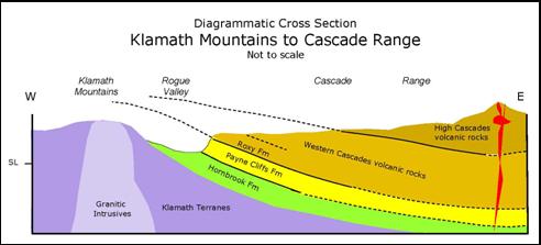
10 million years ago the Klamath Mountains were uplifted and all of the
overlying rocks were tilted east and exposed to erosion. The soft sedimentary
rocks of the Hornbrook and Payne Cliffs Formations were eroded to form Rogue
Valley. The volcanic rocks of the Western Cascades cap the east side of Rogue
Valley and extend east to where they are covered by the volcanic rock of the
High Cascades, which form the crest of the range. |
|
The
Cascade Range extends from Lassen Peak in northern California through Oregon
and Washington to Mt. Garibaldi and Mt. Meager in British Columbia. The range
is formed from a pile of volcanic rocks from one to two miles thick that have
accumulated in this area over the last 40 million years through the eruptions
of thousands of volcanoes. With each eruption, the younger volcanic rocks
were deposited on top of the older volcanic rocks, so that the oldest rocks
now lie at the bottom of the heap and the youngest rocks are on top. The
volcanic eruptions continue into the present, and within the next few million
years the currently active volcanoes will become extinct, erode, and then be
covered by still younger volcanoes. The
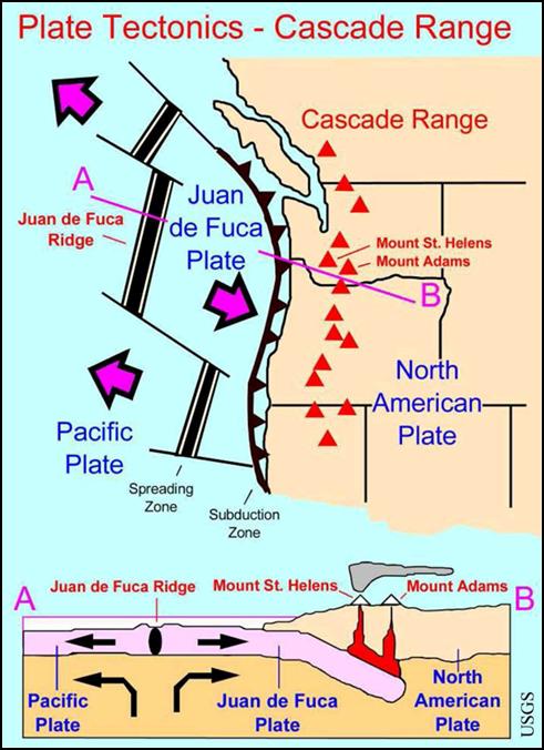
Cascade volcanoes were formed during the collision between the west moving
North American plate and the east moving Juan de Fuca plate along the
subduction zone that forms the boundary between the two plates. During the
collision, the lighter North American plate overrides the heavier Juan de
Fuca plate, forcing the Juan de Fuca plate deep below the North American
plate. At depths of about 60 miles, increasing heat and pressure squeeze
water out of the subducted plate and the water lowers the temperature of the
surrounding rock, which melt and form magma. The magma, which is less dense
than the overlying rocks, rises to the surface where it erupts as a volcano
along a string of volcanoes parallel to the trench. Most
of the rocks in the Cascade Range are formed by the following processes: Basalt lava flows occur where there has been little
change in the composition of the basalt magma that was formed deep in the
subduction zone. These lava flows are very fluid and can extend many miles
from the vent. Basaltic magma
containing water will typically erupt in a shower of dark cinders an
inch or so in diameter that have lots of holes formed by the expanding gas.
These cinders usually form a cinder cone around the vent. Eruptions of andesite
magma occur
when the original basalt magma is altered to andesite magma as it picks up
more silica as it rises through overlying continental plate. The silica
stiffens the magma so that it does not easily flow. Andesite magmas often
erupt as sticky lava flows that do not travel far from the vent. The eruption
may also throw out volcanic bombs and form agglomerates, blocks of volcanic
material composed largely of volcanic bombs. Eruptions of andesite
magma containing water. If the andesite magma is very stiff and contains
significant water when it reaches the surface, the eruption can be explosive
as the gas tries to escape from the stiff magma. The eruption can throw ash
high above the volcano and the ash can cover large areas with thick “ash
falls” of white tuff. Ash and pumice that is thrown into the air can also
flow down the slopes of the volcano in seething clouds buoyed by the
expanding gas. These “ash flows” can travel fast and cover many miles. If the
ash flow is thick enough and hot enough the ash melts and is recrystallized
to form hard “welded tuff.” Other rocks common in volcanic areas include
lake deposits, and lahars, mudflows of volcanic debris. Western
Cascades The
rocks of the Western Cascades are well exposed in road cuts along most of the
highways that go east from the Rogue Valley into the Cascades. In these road
cuts look for lava flows with columnar jointing, agglomerates, tuffs, lake
beds, lahars and mudflows. You will not see volcanoes—they have been eroded.
But you can see dikes that once fed the volcanoes. In places, the rocks have
been altered by steam and hot water to form clay and red and yellow stains in
the rocks. Here’s
were to see the rocks in the road cuts:
Dead Indian Memorial Road from east of Pompadour Bluff to
Hyatt Prairie Road. Crater Lake Hwy. (HW 62) from Eagle Point to Lost Creek
Lake, then the northwest side of Lost Creek Lake to Mill Creek Dr. Green Springs Hwy. (HW-66) from the east end of Emigrant Lake
to Green Springs. Lake of the Wood Hwy. (HW-140) from Eagle Point to few miles west
of Fish Lake. I-5 S at Siskiyou Summit has road cuts in mudflows that
contain pieces of charcoal. High
Cascades Most
of the volcanic activity in the High Cascades has occurred during the last
five million years, and many of the volcanic features are relatively fresh.
The High Cascades include all of the highest volcanoes and all of the active
volcanoes in the range. Most of these volcanoes are formed from andesite, and
most are built on top of a platform of basaltic shield volcanoes. The basalt
lava flows that form this platform are well exposed in many places in the
High Cascades. Volcanic activity often blocks established rivers and creeks,
forming numerous lakes. Here are some places to see these volcanic features: Brown Mountain (7311’) is an andesitic shield
volcano with a small cinder cone on top. The volcano erupted about 20,000
years ago.
Crater
Lake
lies in a caldera formed during the eruption of Mt. Mazama 7700 years ago.
This is the deepest lake in the United States (1932’). Diamond Lake was formed when thick flows of pumice and
ash from the eruption of Mt. Mazama flowed north into the valley between Mt.
Bailey and Mt. Thielsen and impounded the drainage in the valley. The lake is
filled by springs and streams. Diamond Lake Highway (HW-230). Ash and pumice flows formed
during the eruption of Mt. Mazama are well exposed in many large white road
cuts along Diamond Lake Highway (HW-230) from Union Creek to Diamond Lake.
Look for pumice and charcoal in the white volcanic ash. Howard Prairie Reservoir and Lost
Creek Reservoir both lie along the contact between old volcanic rocks of the Western
Cascades and younger lava flows of the High Cascades. Lake of the Woods is a natural lake located in a low
spot in volcanic rocks near the crest of the High Cascades. The lake is
filled mainly by groundwater. Mt. McLoughlin (9495’) is a composite volcano
formed from andesite lava flows, blocky andesite, agglomerates and other
volcanic debris. The core of the volcano is a cinder cone and the volcano
sits on a broad basalt shield volcano. Mt. McLoughlin was active about 200,000
years ago, but has had no recent volcanic activity. During the ice ages,
glacial ice carved a cirque on the east side of the volcano. Mt. Thielsen (9182’) erupted over one million years
ago. The sharp top of the peak was shaped by glacial erosion during the ice
ages. At
Natural Bridge the Rogue River disappears into a
lava tube for a short distance and the top of the lava tube forms a bridge
across the river. At
Rogue Gorge the Rogue River cuts a deep narrow gorge
through 1.25 million year old lava flows as it follows lava tubes in the lava
flow. External
Websites USFS:
Rogue-Umpqua Scenic Byway Wikipedia:
Cascade Volcanoes,
Cascadia Subduction Zone,
Return to:
Rogue Valley Area |

|
Klamath Mountains 1. Applegate Dam 2. Collier
Tunnel 3. Eight Dollar Mountain 4. Hellgate Canyon 5. Mt. Ashland 6. Oregon Caves 7. Smith River 8. Upper Applegate Road Rogue Valley 10. Barneburg Hill 11. Emigrant Lake 12. I-5 S (MM-6) 13. Pompadour Bluff 14. Roxy Ann Peak 15. Table
Rocks |
|
Cascade Range 20. Brown Mountain 21. Crater Lake 22. Dead
Indian Memorial Rd 23. Diamond Lake 24. Diamond Lake Hwy. 25. Green Springs Hwy. 26. Howard Prairie Reservoir 27. Lake of the Woods 28. Lake of the Wood Hwy. 29. Lost Creek Reservoir 30. Mt. McLoughlin 31. Mt. Thielsen 32. Natural Bridge 33. Rogue Gorge 34. Siskiyou
Summit |