|
Geologic Trip, Rogue Valley Table Rocks |
|
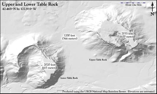
Upper Table Rock and Lower Table
Rock are two horseshoe-shaped buttes located on the west side of the Rogue
Valley immediately north of the Rogue River. These two buttes are excellent
examples of inverted
topography, where the bottom of an older
river valley now forms the top of the mountain. The Table Rocks are capped by
a 200-foot thick lava flow that came into this area from the High Cascades
about seven million years ago and covered much of the floor of the ancestral
Rogue Valley at that time. After the lava flow, the Rogue River established a
new channel and continued to erode and deepen the Rogue Valley so that the
floor of the valley is now 600 feet lower than it was at the time of the lava
flow. Not only the floor of the Rogue
Valley was eroded, but the land surfaces in the Rogue Valley and Bear Creek
Valley would have eroded at about the same rate, wherever the tributary
creeks and streams to the Rogue River maintained their gradient. This may seem
like a lot of erosion, but it is really not that bad. If you do the math, 600
feet of erosion over seven million years means that the rate of erosion would
have been about one inch per 1000 years. The Klamath Mountains have been
uplifted at about the same rate over the same period. Another way to
appreciate the amount of erosion in the Rogue Valley and Bear Creek Valley is by looking at the
Table Rocks from the top of Barneburg Hill. The channel of the ancestral
Rogue River is at an elevation of 1800 feet at the Table Rocks, over 100 feet
higher than the top of Barneburg Hill. The hill certainly must have been a
few hundred feet higher than the ancestral Rogue River seven million years
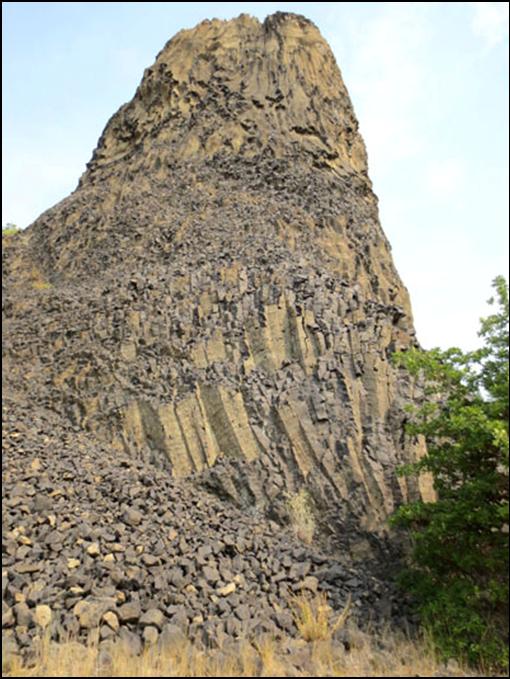
ago. The Table Rock lava flow has
well-developed columnar joints and looks much like a typical basalt flow.
However, based on chemical composition it is classified as an alkaline-rich
andesite. The lava is glassy and nearly black, with distinctive tabular specks
of white plagioclase and small crystals of green olivine and dark augite. The
Table Rock flow ranges from a maximum thickness of 730’ at the south bank of
Lost Creek Lake to about 200’ at the Table Rocks. The top of the lava flow at Table
Rocks is very hard and has not eroded much over the last seven million years.
When you walk on the top of the Table Rocks, you are walking on a land
surface that has not changed much since late Miocene time. However, the soft
sedimentary rocks of the Payne Cliffs Formation below the lava flow are
easily eroded and provide a weak foundation for the flow. Thus, most of the
erosion of the Table Rocks lava flow is from the sides of the lava flow,
where chunks of the flow break off along the columnar joints and make their
way down the slope of the hill. These broken pieces of the flow can be seen
in many places along the lower slopes of the Table Rocks. Places
to See the Rocks The Table Rock lava flow can be
seen along the trails to Lower Table Rock and Upper Table Rock, and also in
road cuts along Highway 62 at Lost Creek Lake: Lower Table Rock Trail head— Drive north from Medford on Table Rock Road to
Wheeler Road. Turn left on Wheeler Road. Trail head is 1/2 mile ahead on the
left. 2.7 miles to top. Upper Table Rock Trail head— Drive north from Medford on Table Rock Road. Turn
right on Modoc Road and continue for 1 mile,
trail head on left. 1.4 miles to top. Road Cuts at Lost Creek Lake—Highway 62 2.0 miles northeast of the turnoff to
McGregor Park has road cuts with excellent exposures of the Table Rock lava
flow. External
Websites Oregon
Geology (Hladky):
Origin of Lava...Table Rock
Wikipedia:
Upper and Lower Table Rock Return to:
Rogue Valley |
|
The Table Rock andesite lava flow
is well exposed at the rock quarry on the south side of Lost Creek Lake. In
this area the lava reaches a maximum
thickness of 730 feet where it fills a narrow paleochasm of the ancestral
Rogue River. The lower part of this lava flow is exposed in Highway 62 road
cuts along the south side of Lost Creek Lake. |
|
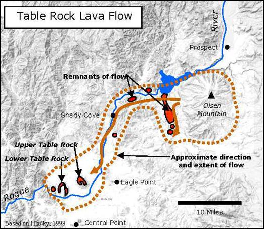
The lava that caps the Table Rocks
came from volcanic vents near Olsen Mountain in the High Cascades and flowed
west about 40 miles, generally following the ancestral Rogue River and
spreading out to cover much of the floor of the ancestral Rogue Valley.
Remnants of the lava flow also occur in a few other places, as shown of the
map. |
|
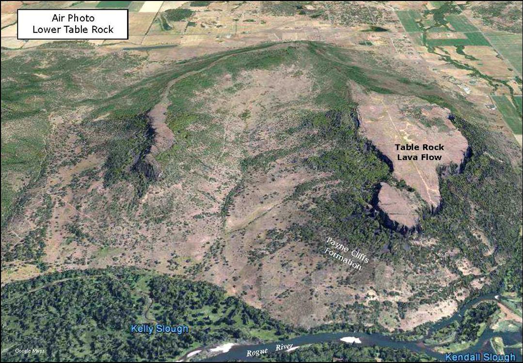
The horseshoe shape of Upper Table
Rock and Lower Table Rock likely follows meanders of the ancestral Rogue
River. |
|
Google Maps |