|
Rogue Valley Area Cascadia
Earthquake-Potential Damage |
|
Modified from USGS |
|
Cascadia subduction zone |
|
Great Earthquake Very Large Earthquake |
|
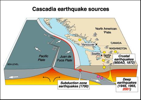
Cascadia Subduction Zone Western
Oregon and Washington lie along the collision zone between two of the large
crustal plates that cover the surface of the earth. In this collision, the
North American plate is moving west and is overriding the eastward-moving San
Juan de Fuca plate. The contact area between the plates is referred to as the
Cascadia subduction zone, and most of the movement between the plates
is in this subduction zone. From time to time, the rocks in the subduction
zone suddenly break, causing the rocks to move rapidly and the earth to
shake. During large earthquakes the rocks in the subduction zone can be
offset several tens of feet and uplifted or dropped ten feet or more. When
the sea floor is offset by these movements, large tsunami waves can form and
inundate coastal areas over great distances. Coastal areas may also locally
subside several feet. Cascadia earthquakes are capable of causing extensive
damage over broad areas, and should be considered a serious hazard for
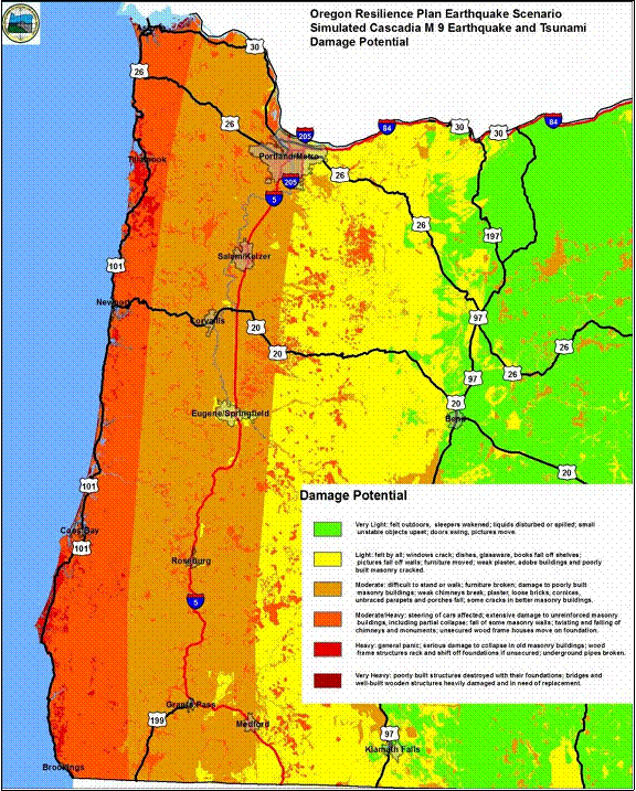
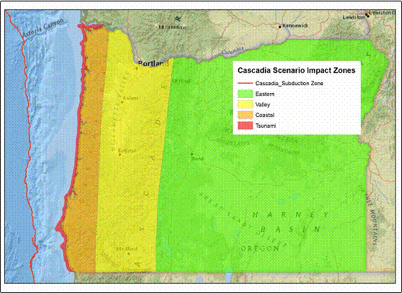
residents of Oregon and Washington. Oregon Resilience Plan Recognizing
the threat that a large earthquake on the Cascadia subduction zone poses to
Oregon, the State of Oregon commissioned preparation of the Oregon Resilience
Plan to help guide state policy in preparing for a large earthquake. The
map on the right, from the Oregon Resilience Plan, shows potential damage
that could occur in Oregon from a Great Earthquake (M9) along the Cascadia
subduction zone. An earthquake of this size would be comparable to the
Japanese Tohoku Earthquake of 2011 off the east coast of Honshu. Strong
shaking could last from two to four minutes. The shaking would be strongest
along the coast near the fault and decrease eastward away from the fault.
Locally, damage would be greater in areas of unconsolidated water-saturated
sediments, in areas prone to landslides, and in low-lying coastal areas
within reach of tsunamis. In
general, the map shows: Coastal
areas would have Moderate to Heavy Damage in most areas, with local areas of
Very Heavy Damage. The
I-5 corridor would mostly have Moderate Damage, with local areas of Heavy
Damage. The
Rogue Valley would have Light to Moderate Damage, with local areas of Heavy
Damage. The
Cascade Range would have Light Damage, with Moderate to Heavy Damage locally.
Eastern
Oregon would have Very Light Damage, with some areas of Moderate Damage. Impact Zones Based
on the expected damage from a M9 earthquake, the Oregon Resilience Plan
divides Oregon into four distinct zones: The Tsunami Zone,
where severe shaking and tsunami inundation would cause near total damage and
threaten the lives of thousands of residents. The Coastal Zone,
where severe shaking and damage to transportation systems would severely disrupt
and isolate communities and where the major challenge after the earthquake
would be to
keep the population sheltered, fed and healthy. The Valley Zone,
where widespread moderate damage would severely disrupt daily life and commerce
and where restoring services to business and residents would be the main
priority. The Eastern zone
where light damage would allow rapid restoration of services and functions, and where
communities would become critical hubs for the movement of response recovery and
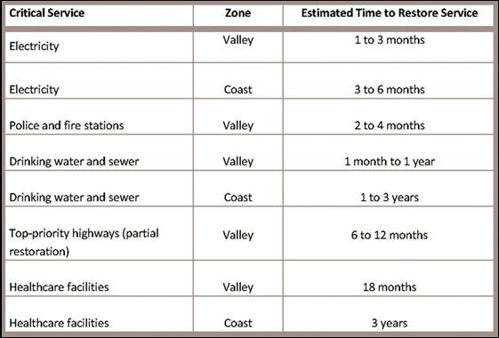
restoration personnel and materials for the rest of the state. Restoration of Critical Services The
Oregon Resilience Plan includes estimates of the time needed to restore
critical services to the affected areas following a M9 earthquake along the
Cascadia subduction zone (above). In the Valley Zone, which includes most of
the Rogue Valley, these estimates are 1 to 3 months for electricity, 1 month
to a year for drinking water and sewer, and 18 months for healthcare
facilities. Restoration of critical services in the Coast Zone would take
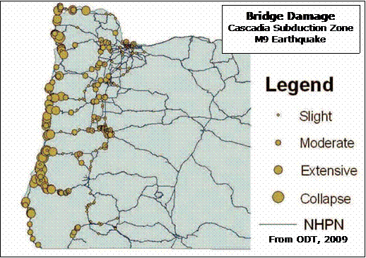
significantly longer. Oregon Highways Based
on a report by the Oregon Department of Transportation, many of Oregon’s
highway bridges would be subject to significant damage during a major
earthquake (Seismic Vulnerability of
Oregon State Highway Bridges). Most of these bridges were build between 1950
and 1980 when modern seismic design specifications were not available and
before the Cascadia subduction zone was recognized as a major earthquake
risk. The
map on the right, from the ODT report, shows potential damage to Oregon
highway bridges from a simulated M9 earthquake along the
Cascadia subduction
zone.
Most of the major bridge damage would be along the coast, along the I-5
corridor and along the highways between I-5 and the coast. Restoring these
highways is critical to recovery of the affected areas. External Websites FEMA,
Earthquake Publications Oregon
Department of Transportation, 2009,
Seismic Vulnerability of Oregon
State Highway Bridges USGS,
Great Alaska Earthquake and Tsunami
(9.2M), 1964 USGS,
Orphan Tsunami of 1700 |
|
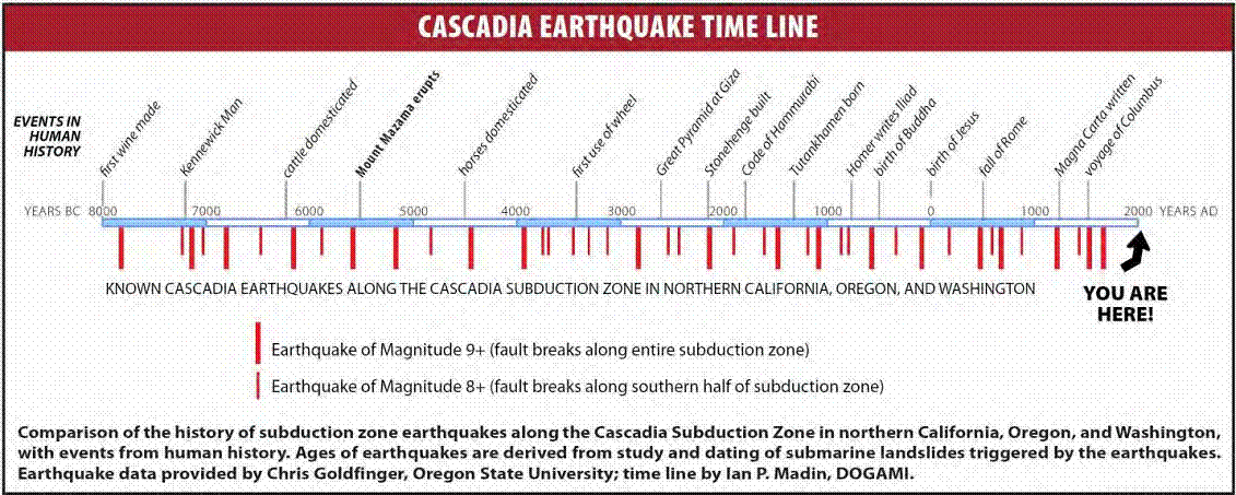
Cascadia Earthquake Major
earthquakes along the Cascadia subduction zone tend to occur every several
hundred years, as shown on the above Time Line. The last major earthquake was
in January of 1700 and was large enough to send tsunami waves across the
Pacific and devastate coastal areas of Japan (Orphan Tsunami of 1700). Most
seismologists agree we are due for another major earthquake any time now.
There is no way to predict when the earthquake will occur, but experts have
calculated the following odds of occurrence during the next 50 years: 7-15% for a “Great Earthquake” (M9+,
with fault breaking along entire subduction zone); 37% for a “Very Large Earthquake” (M8+,
with fault breaking along southern part of Oregon). |